Plan Overview
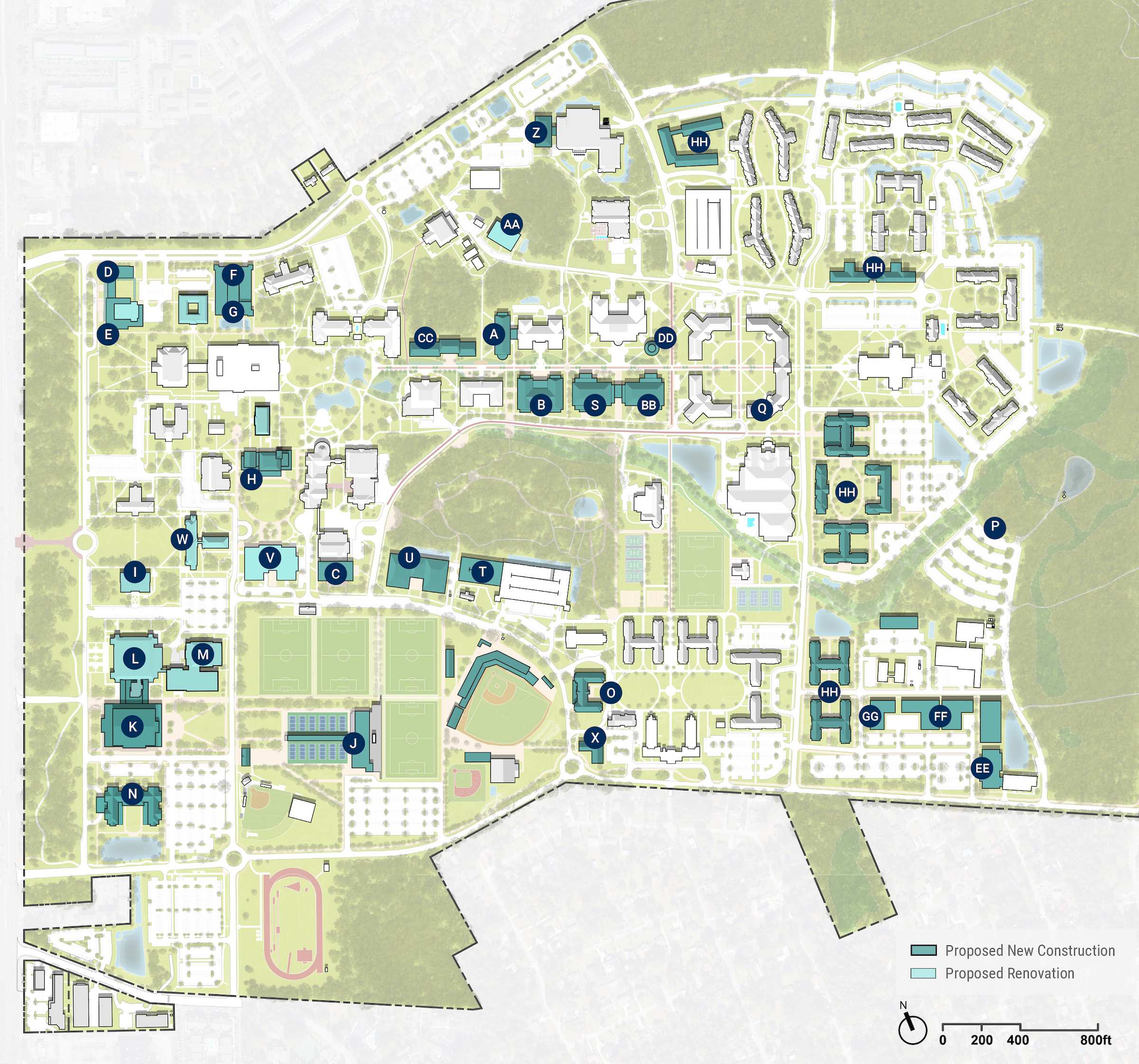
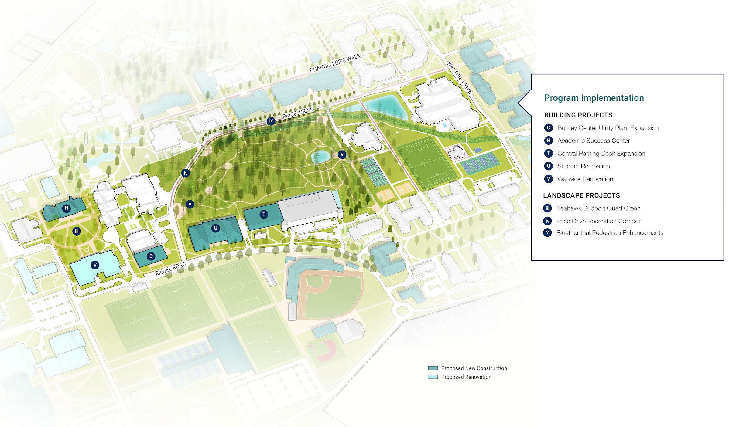
Building Project List
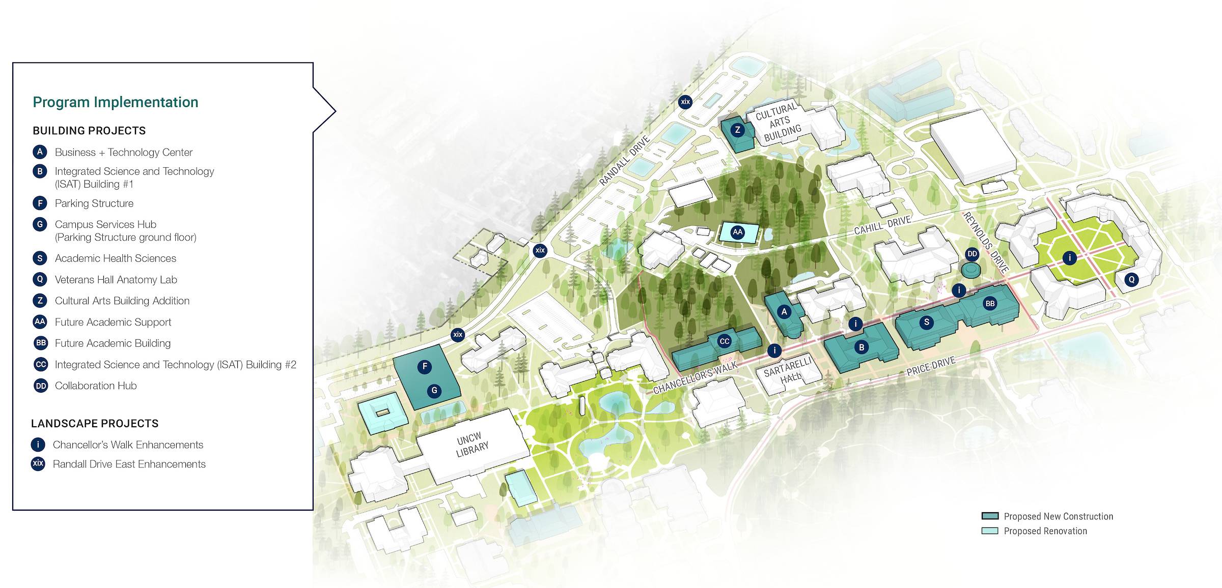
- Business + Technology Center
- Integrated Science and Technology (ISAT) Building #1
- Burney Center Utility Plant Expansion
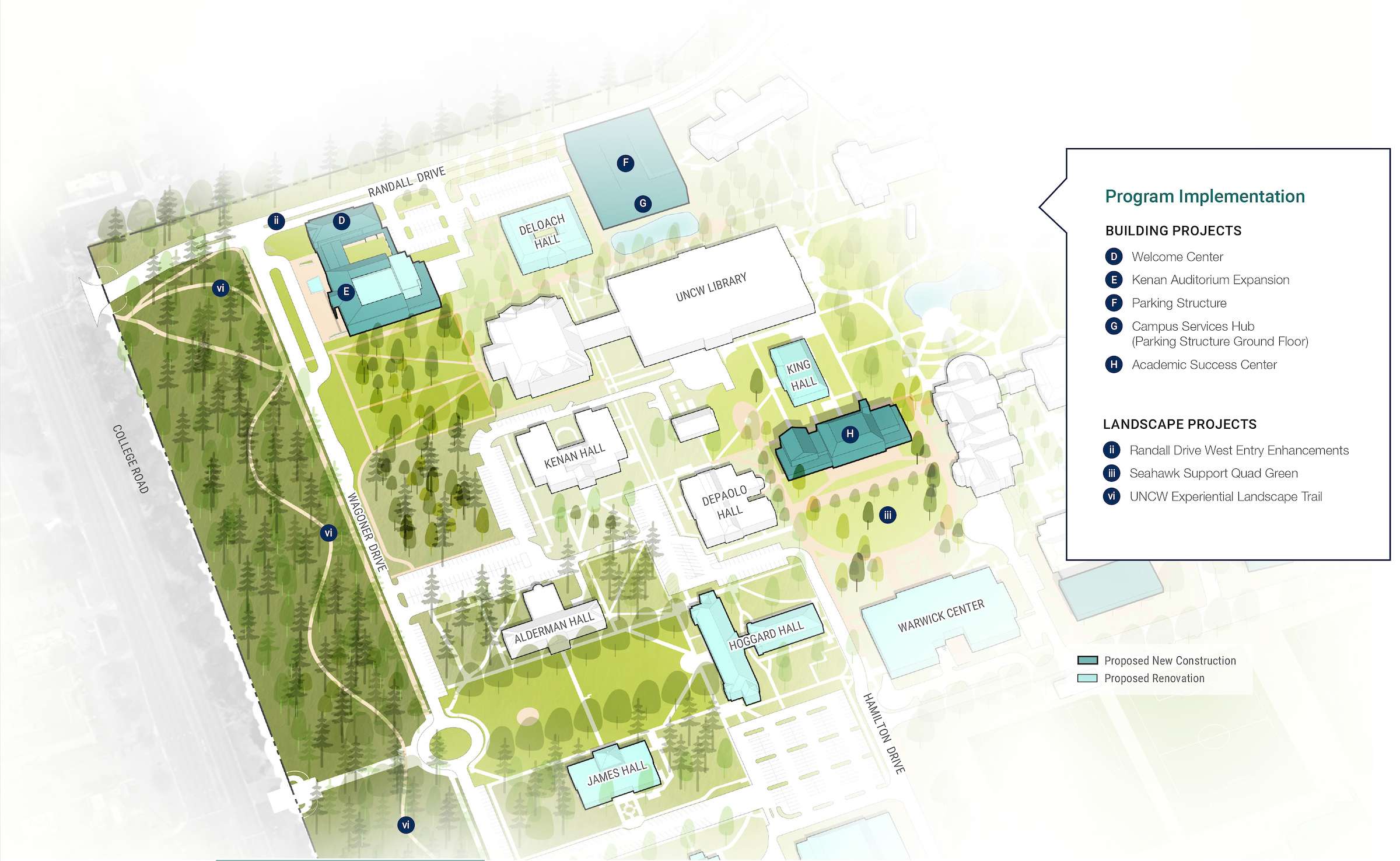
- Welcome Center
- Kenan Auditorium Expansion
- Parking Structure
- Campus Services Hub (Parking Structure ground floor)
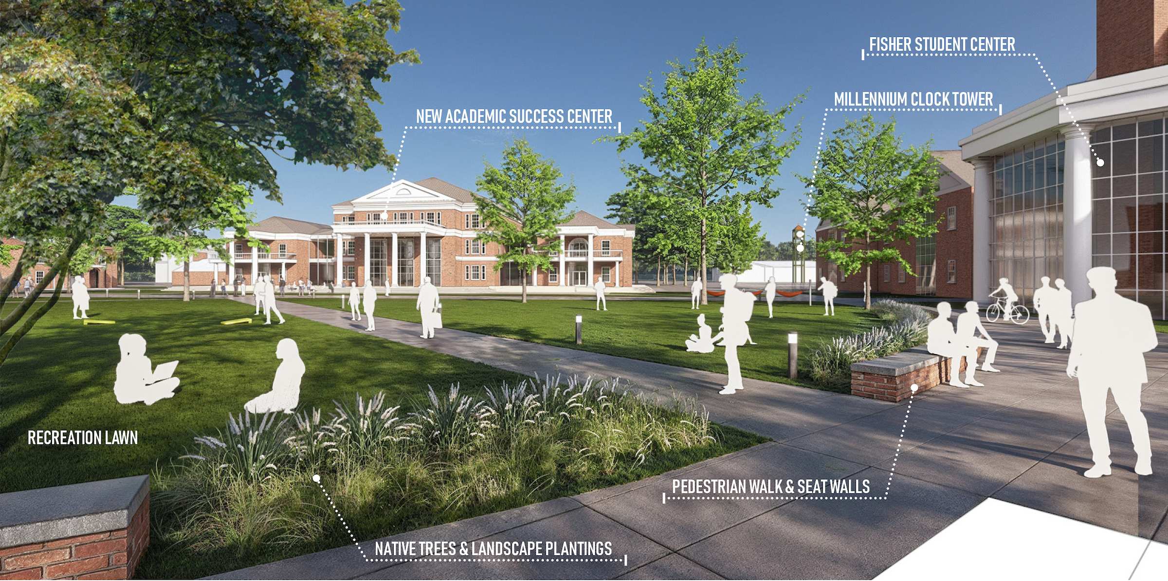
- Academic Success Center
- Renos/Reshuffles assoc. w/ Seahawk Support/Academic Success
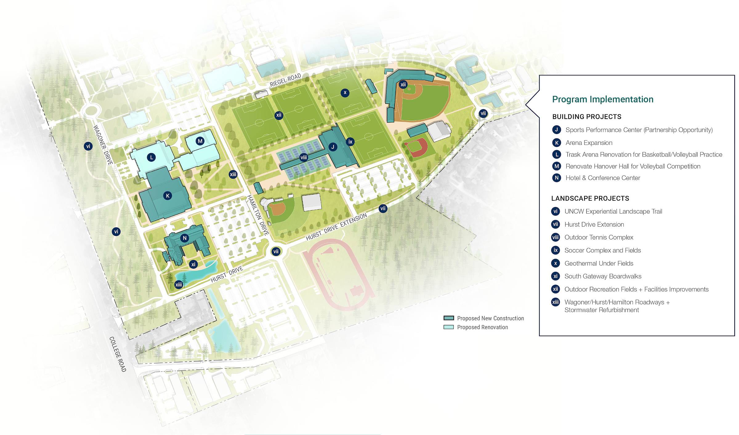
- Sports Performance Center (Partnership Opportunity)
- Arena Expansion
- Trask Arena Renovation for Basketball/Volleyball Practice
- Renovate Hanover Hall for Volleyball Competition
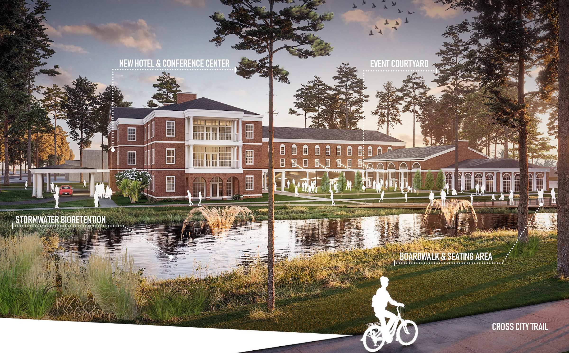
- Hotel & Conference Center
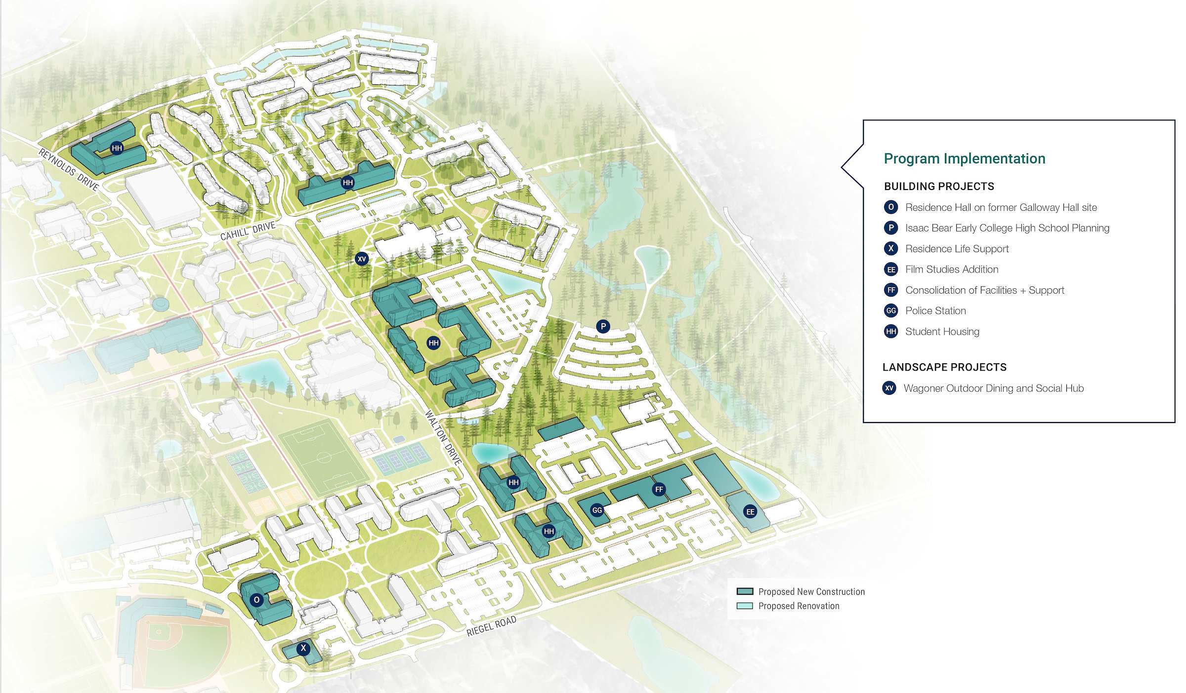
- Residence Hall on former Galloway Hall site
- Isaac Bear Early College High School Planning
- Veterans Hall Anatomy Lab
- Alderman Hall and King Hall Renovations
- Academic Health Sciences
- Central Parking Deck Expansion
- Student Recreation
- Warwick Renovation
- Hoggard Hall Program Reshuffling
- Residence Life Support
- Cultural Arts Building Addition
- Future Academic Support
- Future Academic
- Integrated Science and Technology (ISAT) Building #2
- Collaboration Hub
- Film Studies Addition
- Consolidation of Facilities + Support
- Police Station
- Student Housing
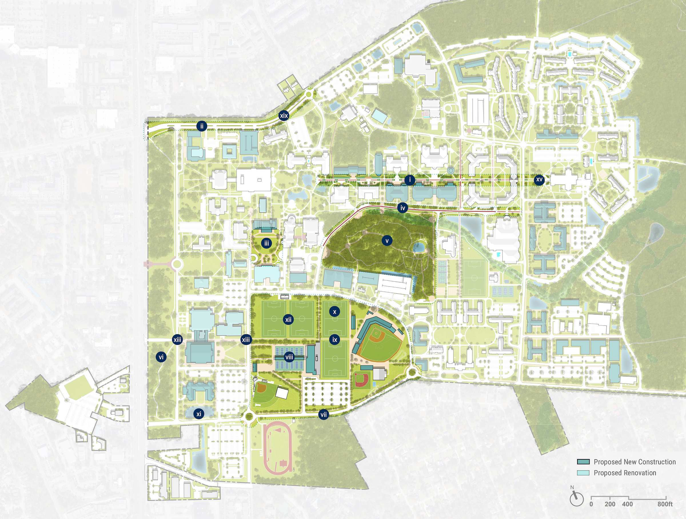
Landscape Project List
- i. Chancellor's Walk Enhancements
- ii. Randall Drive West Entry Enhancements
- iii. Seahawk Support Quad Green
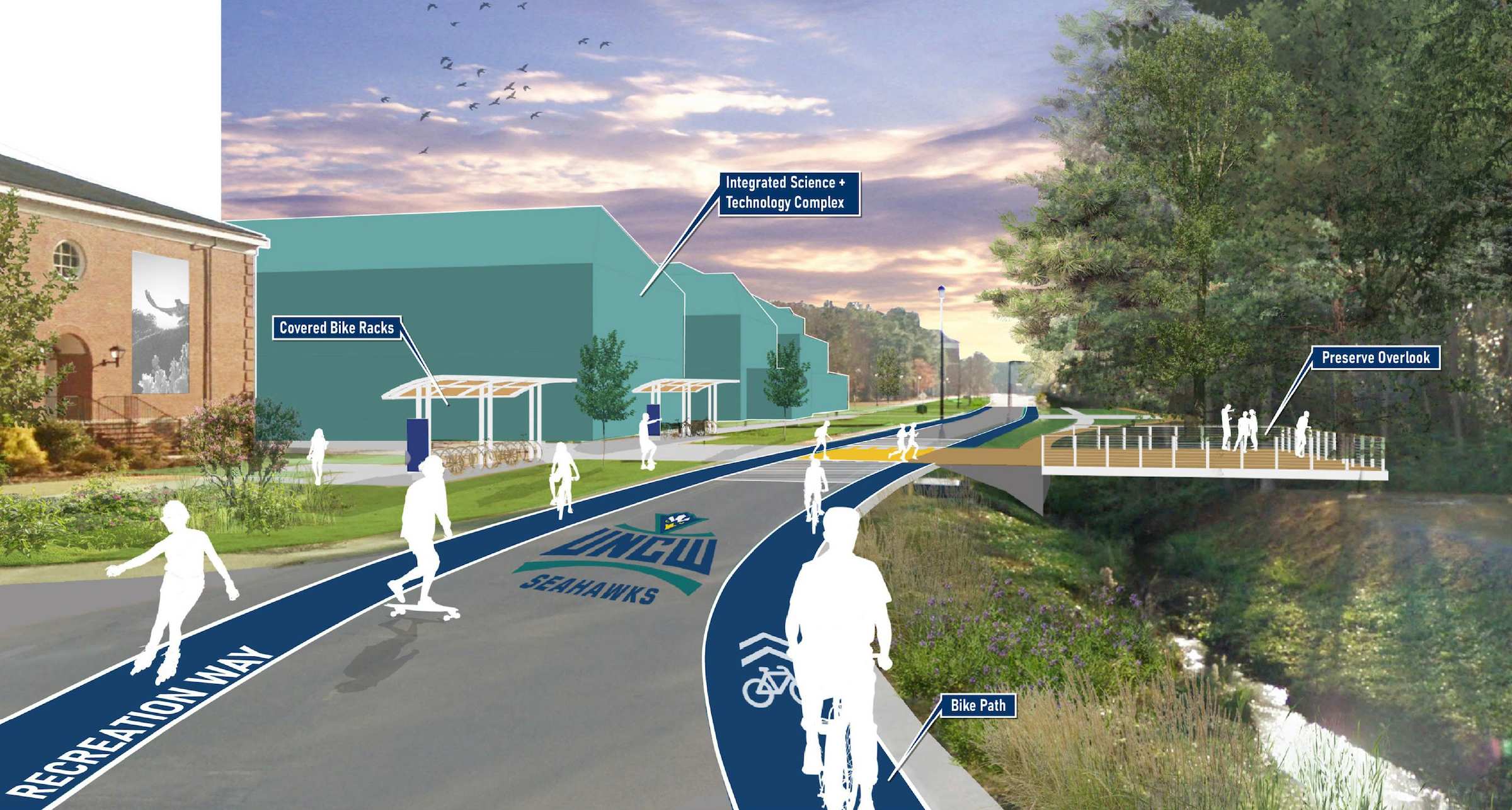
- iv. Price Drive Recreation Corridor
- v. Bluethenthal Pedestrian Enhancements
- vi. UNCW Experiential Landscape Trail
- vii. Hurst Drive Extension
- viii. Outdoor Tennis Complex
- ix. Soccer Complex and Fields
- x. Geothermal Under Fields
- xi. South Gateway Boardwalks
- xii. Outdoor Recreation Fields + Facilities Improvements
- xiii. Wagoner/Hurst/Hamilton Roadways + Stormwater Refurbishment
- xiv. Randall Drive East Enhancements
- xv. Wagoner Outdoor Dining and Social Hub
Welcome + Cultural Engagement
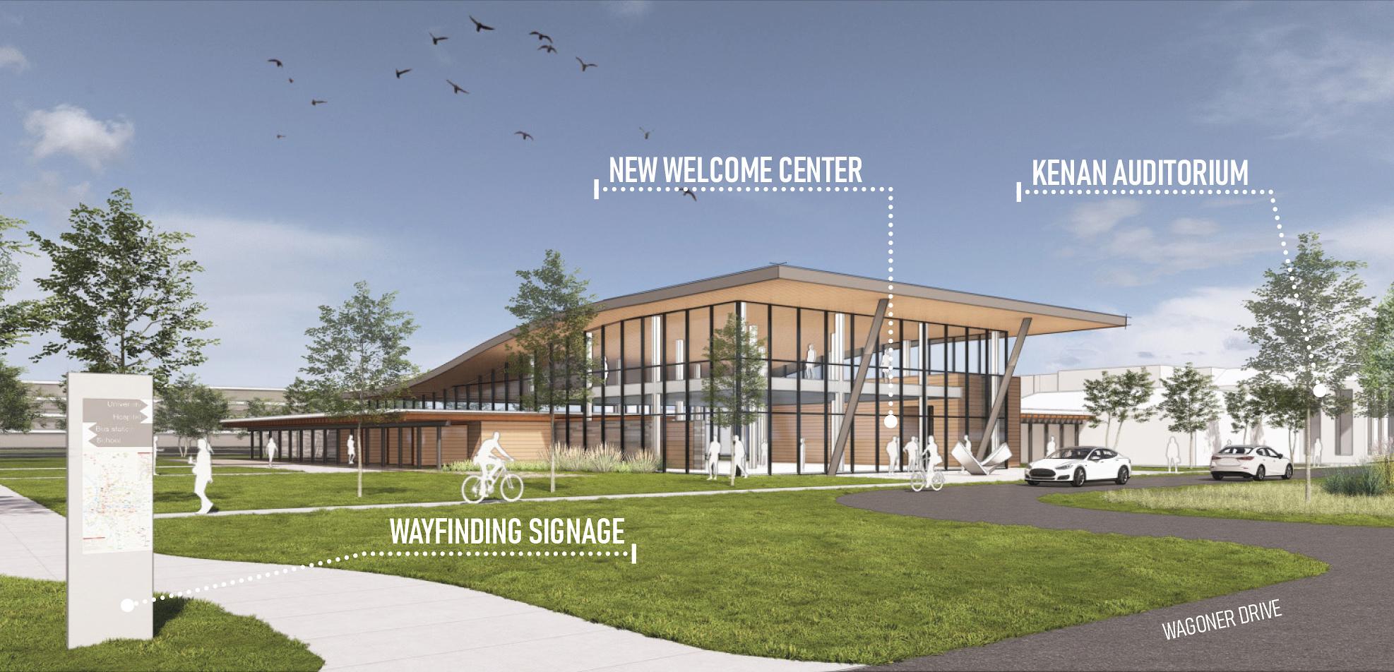
The reimagined campus gateway will enhance the campus arrival experience with iconic UNCW branding, enhance the campus arrival experience, and provide community engagement development opportunities. Road improvements along Randall Drive with expanded parking will provide ease of access and wayfinding for campus visitors and daily users.
The North Gateway district boasts a new Welcome Center at the most prominent campus corner of Randall and Wagoner Drives and unites with a renovated Kenan Auditorium for performing arts to intentionally bring together campus visitors, alumni, community, and academics. Along with the newly expanded library, this n will frame a new outward facing civic green events space. This new green will strengthen the frontage along Wagoner Drive in combination with enhancements to the historic quad at Hoggard Hall. The Pine Buffer along College Road, a unique landscape feature containing the Cross City Trail, will be preserved for its cultural significance and enhanced with interpretive historical/public art displays.
Seahawk Community + Athletics
The new South Gateway will feature the UNCW coastal brand, enhance the campus arrival experience, feature athletics and hospitality destinations, and provide multiple future development opportunities. This reimagined district of campus will house a hotel and conference center serving as a hub for visitors and the campus community, with the ability to host large events overlooking the newly expanded pond and boardwalks.
A new arena connected to the renovated Trask Coliseum fronts Wagoner Drive, expanding the civic presence of UNCW at this important campus edge while providing much needed space upgrades. An expanded Athletics Village will serve as a connection between athletics, the community and the core of campus.
A more pedestrian friendly district is created by rethinking street hierarchy, limiting access to internal streets and promoting multimodal use. The Hurst Drive extension from the South College Road entry to the east side of campus will provide a southern leg to a loop road, keeping cars at the perimeter of campus.
Academic Hub
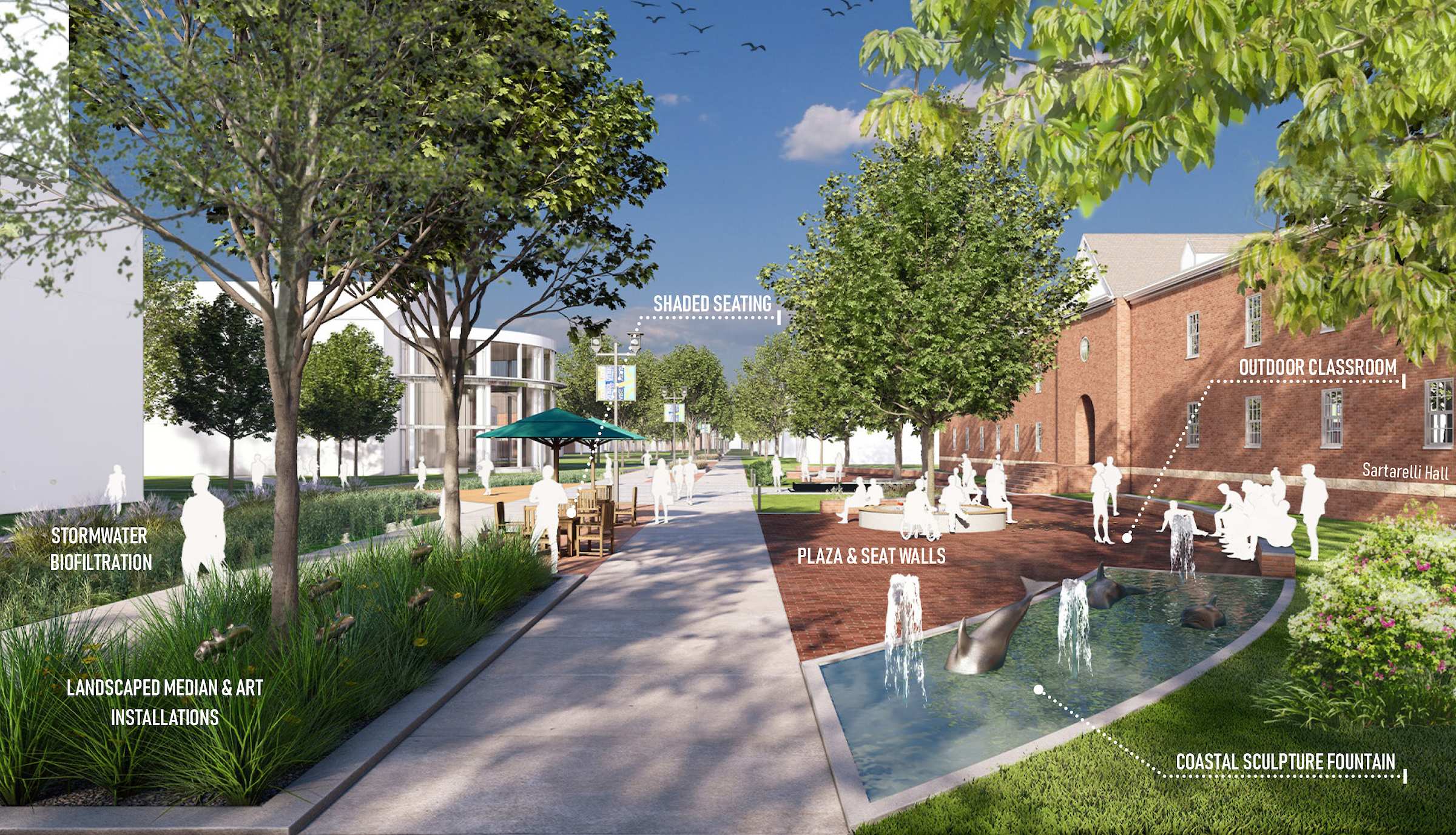
Chancellor's Walk is conceived as the academic Main Street of campus. The plan strengthens this concept with new facilities proposed on infill sites to complete this iconic and heavily traveled spine. New facilities are designed to foster interdisciplinary collaboration and showcase academic programs through shared meeting and social spaces at the ground level.
Outdoor spaces along Chancellor's Walk and throughout the district are activated to provide more teaching resources through outdoor classrooms and further promote a shared sense of social belonging. By concentrating new facilities along Chancellor's Walk, existing natural areas are preserved and usable as a learning lab.
Enhanced north-south paths through the district create clear connections to campus hubs within and beyond the Academic District and provide activity nodes along the way. Micromodal transportation is restricted along Chancellor's Walk and focused along Cahill Drive to the north and Price Drive to the south. Extended Randall Drive enhancements keep auto traffic at the perimeter of campus and include a new traffic circle at the Racine Drive entry.
Connection + Wellness
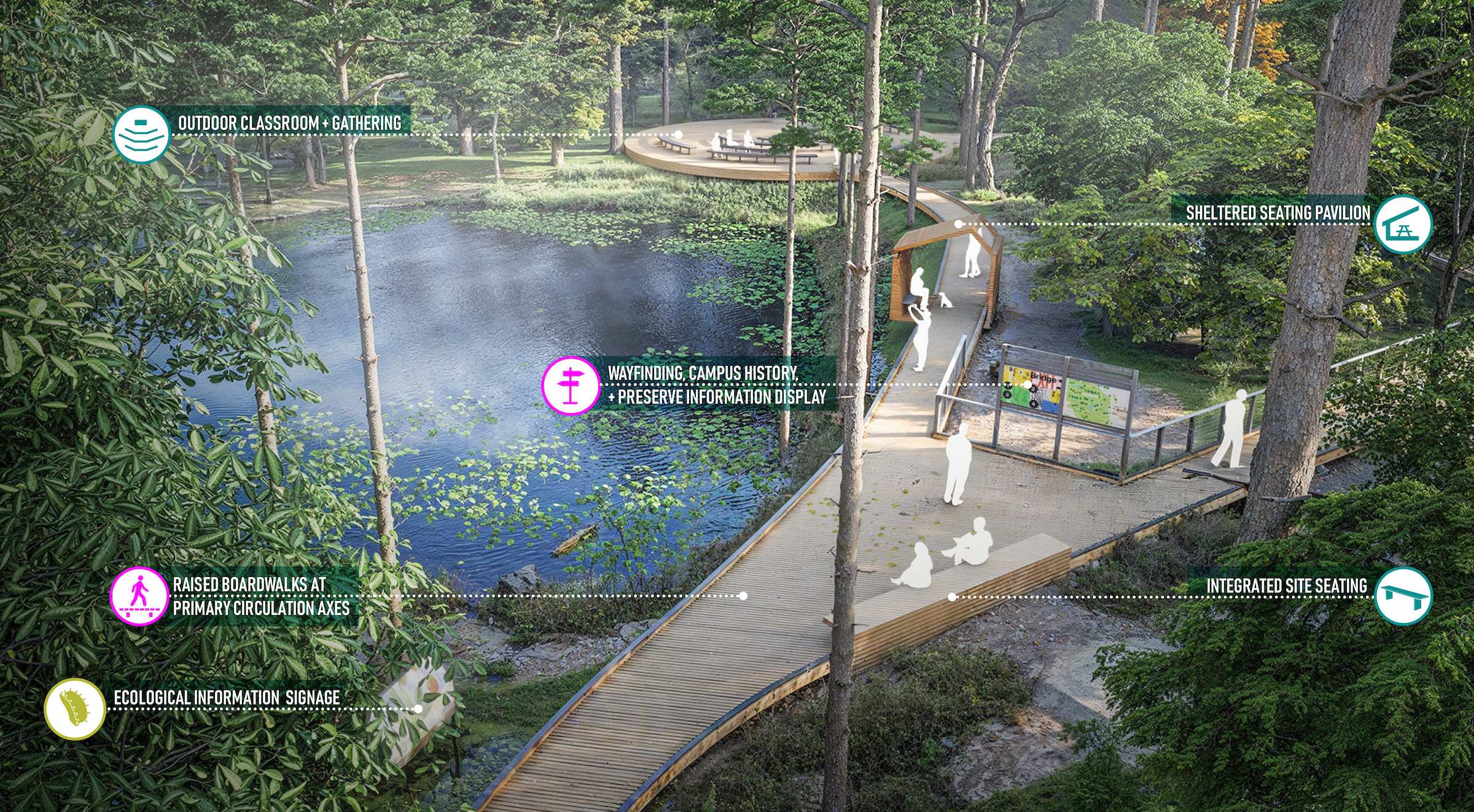
The Student Life Core is composed of three distinctly unique campus zones: the Campus Life Hub featuring social, dining, and student support spaces on the west, Bluethenthal Wildflower Preserve, and the Campus Recreation Hub on the east.
Bluethenthal is reconceived as a unique and accessible natural amenity in the middle of campus. An outdoor classroom on the pond and small areas for reflection, and interpretive signage throughout provide educational opportunities. Price Drive is reconceived as Recreation Way, a multimodal corridor connecting east and west campus on the north side of Bluethenthal. Several overlook spaces provide shaded space along the path and views into the reserve.
The Seahawk Support Quad is a new concept to unite student services around a central space focused on Wellness. The quad is surrounded by Student Health, Fisher Student Union, a reinvigorated Warwick Center for student engagement and a new Academic Success Center.
A new Campus Recreation facility brings a fitness/wellness outlet to the Campus Life Hub. Complementary to the Campus Rec Hub to the east, this location offers partnership opportunities with athletics, intramural and club sports, and private wellness groups. The recently completed outdoor recreation complex creates a dynamic outdoor environment adjacent to the residential villages.
Seahawk Experiences
With a future goal to house approximately 40% of in-person students, the plan provides a flexible phased vision for short-term and long-term housing sites to add nearly 1,500 new beds. The overall vision is to strengthen the existing “Nest” Village with a new approximately 350-bed residence hall on the former Galloway Hall site and to provide multiple options for future housing communities. Potential redevelopment opportunities at the existing University Suites and Tin City sites would provide a denser and more efficient use of valuable campus land while creating distinct communities. Smaller infill sites provide longer term opportunities to expand and complement existing residential villages north of Wagoner Dining Hall.
The space in front of Wagoner Dining at the terminus of Chancellor's Walk is reconceived as an outdoor dining and social hub for the Residential District. Future buildings front the space and add ground floor student life spaces to further enliven the space. Connections to the Academic District are reinforced by multimodal paths at Cahill and Price Drives. The new Hawk Walk connects campus from north to south.
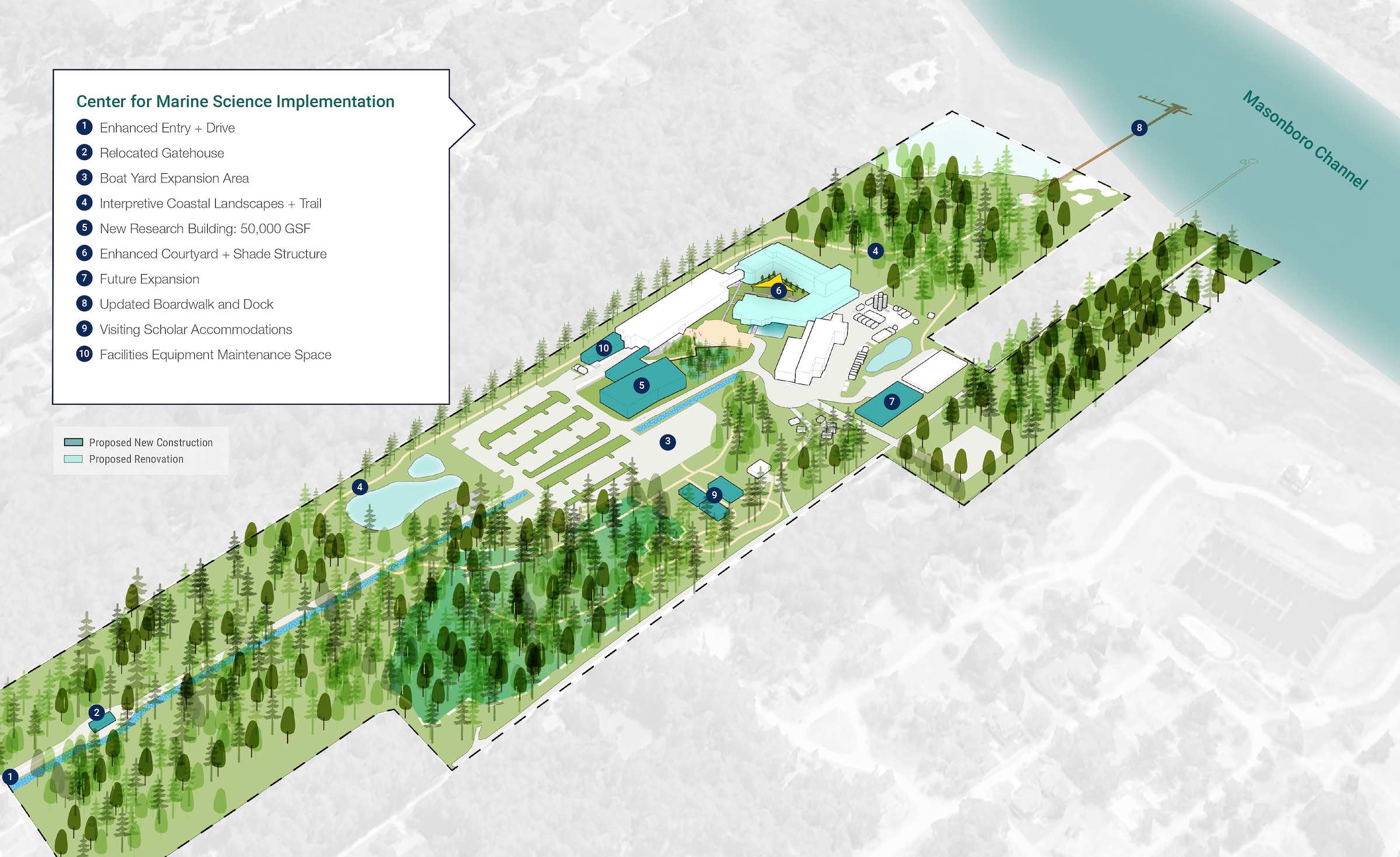
Established in 2000, the Center for Marine Science (CMS) campus is six miles and approximately a 15- minute drive from the main campus in the Myrtle Grove neighborhood of Wilmington with deep water access along the Masonboro Channel. The original CMS classroom and research facilities have grown over time to include additional office, support, research and small business startup space.